
File:Edinburgh tramway map.svg

此SVG文件的PNG预览的大小:800 × 259像素。 其他分辨率:320 × 104像素 | 640 × 207像素 | 1,024 × 331像素 | 1,280 × 414像素 | 2,560 × 828像素 | 850 × 275像素。
原始文件 (SVG文件,尺寸为850 × 275像素,文件大小:202 KB)
摘要
| 描述 |
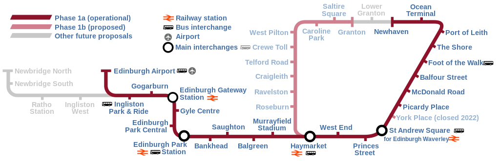
English: Map of the Edinburgh Trams system, showing the as built line (opened May 2014) alongside the various proposed lines that were ultimately abandoned or postponed indefinitely. |
| 日期 | |
| 来源 | 自己的作品 |
| 作者 | DavidArthur |
许可协议
我,本作品著作权人,特此采用以下许可协议发表本作品:

|
已授权您依据自由软件基金会发行的无固定段落及封面封底文字(Invariant Sections, Front-Cover Texts, and Back-Cover Texts)的GNU自由文件许可协议1.2版或任意后续版本的条款,复制、传播和/或修改本文件。该协议的副本请见“GNU Free Documentation License”。 |
This file is licensed under the Creative Commons Attribution-Share Alike 4.0 International, 3.0 Unported, 2.5 Generic, 2.0 Generic and 1.0 Generic license.
- 您可以自由地:
- 共享 – 复制、发行并传播本作品
- 修改 – 改编作品
- 惟须遵守下列条件:
- 署名 – 您必须对作品进行署名,提供授权条款的链接,并说明是否对原始内容进行了更改。您可以用任何合理的方式来署名,但不得以任何方式表明许可人认可您或您的使用。
- 相同方式共享 – 如果您再混合、转换或者基于本作品进行创作,您必须以与原先许可协议相同或相兼容的许可协议分发您贡献的作品。
您可以选择您需要的许可协议。
文件历史
点击某个日期/时间查看对应时刻的文件。
| 日期/时间 | 缩略图 | 大小 | 用户 | 备注 | |
|---|---|---|---|---|---|
| 当前 | 2023年6月17日 (六) 14:58 | 850 × 275(202 KB) | Cnbrb | fix text embedding | |
| 2023年6月17日 (六) 14:30 | 850 × 275(159 KB) | Cnbrb | newhaven branch now operational; typographical and symbolic improvements | ||
| 2020年5月11日 (一) 14:06 | 850 × 275(88 KB) | Angryskies | '''West End - Princes Street''' tram stop renamed to '''West End''' | ||
| 2020年4月21日 (二) 20:17 | 850 × 275(90 KB) | Angryskies | Updated details of line to Newhaven under construction. | ||
| 2017年9月25日 (一) 13:06 | 850 × 275(91 KB) | Sladen | Inclusion of Edinburgh Gateway Station. | ||
| 2013年9月28日 (六) 18:08 | 850 × 275(88 KB) | Sladen | Rename "Shandwick Place" to "West End – Princes Street" per {{cite news|url=http://www.edinburghnews.scotsman.com/news/transport/trams-shandwick-place-stop-renamed-princes-street-1-3106746|title=Trams: Shandwick Place stop renamed Princes Street|firs... | ||
| 2013年2月9日 (六) 13:13 | 850 × 275(88 KB) | Sladen | Split Phase 1a (as built) from Phase 1a (not built) and show as dotted line. Reduce prominence of planned stations to focus on as-built section. Tweak key to include difference, and add "Airport" + pictogram for completeness. + remove errornous extr... | ||
| 2013年2月9日 (六) 13:12 | 850 × 275(88 KB) | Sladen | Split Phase 1a (as built) from Phase 1a (not built) and show as dotted line. Reduce prominence of planned stations to focus on as-built section. Tweak key to include difference, and add "Airport" + pictogram for completeness. | ||
| 2007年11月17日 (六) 17:48 | 850 × 275(73 KB) | DavidArthur | {{Information |Description={{en|20px|English A map of the proposed Edinburgh tramway.}} |Source=self-made |Date=17 November 2007 |Author= DavidArthur |Permission= |
文件用途
以下页面使用本文件:
全域文件用途
以下其他wiki使用此文件:
- cs.wikipedia.org上的用途
- cy.wikipedia.org上的用途
- de.wikipedia.org上的用途
- en.wikipedia.org上的用途
- eo.wikipedia.org上的用途
- es.wikipedia.org上的用途
- fi.wikipedia.org上的用途
- fr.wikipedia.org上的用途
- he.wikipedia.org上的用途
- he.wikivoyage.org上的用途
- ja.wikipedia.org上的用途
- www.wikidata.org上的用途