
File:China Tibet location map.svg

此SVG文件的PNG预览的大小:800 × 452像素。 其他分辨率:320 × 181像素 | 640 × 361像素 | 1,024 × 578像素 | 1,280 × 723像素 | 2,560 × 1,446像素 | 2,013 × 1,137像素。
原始文件 (SVG文件,尺寸为2,013 × 1,137像素,文件大小:465 KB)
摘要
| 描述 |
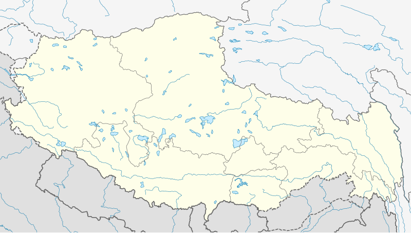
Deutsch: Positionskarte von Autonomes Gebiet Tibet, Volksrepublik China
Quadratische Plattkarte, N-S-Streckung 118 %. Geographische Begrenzung der Karte:
English: Location map of Tibet Autonomous Region, People's Republic of China
Equirectangular projection, N/S stretching 118 %. Geographic limits of the map:
|
|
| 日期 | ||
| 来源 |
自己的作品, using
|
|
| 作者 | NordNordWest | |
| 授权 (二次使用本文件) |
本文件采用知识共享署名-相同方式共享 3.0 德国许可协议授权。
 本文件采用知识共享署名-相同方式共享 3.0 德国许可协议授权。
|
|
| SVG开发 |


文件历史
点击某个日期/时间查看对应时刻的文件。
| 日期/时间 | 缩略图 | 大小 | 用户 | 备注 | |
|---|---|---|---|---|---|
| 当前 | 2020年5月22日 (五) 08:24 | | 2,013 × 1,137(465 KB) | NordNordWest | Reverted to version as of 10:41, 29 January 2019 (UTC); AGAIN: only vector data in this svg please |
| 2020年5月21日 (四) 21:38 |  | 2,013 × 1,137(595 KB) | Geographyinitiative | Reverted to version as of 06:29, 29 January 2019 (UTC) part of Aksai Chin is under TAR jurisdiction | |
| 2019年1月29日 (二) 10:41 |  | 2,013 × 1,137(465 KB) | NordNordWest | Reverted to version as of 12:39, 8 May 2013 (UTC); only vector data in this svg please | |
| 2019年1月29日 (二) 06:29 |  | 2,013 × 1,137(595 KB) | 复旦大学张超 | edit | |
| 2013年5月8日 (三) 12:39 |  | 2,013 × 1,137(465 KB) | NordNordWest | upd | |
| 2013年5月8日 (三) 12:38 |  | 2,013 × 1,137(465 KB) | NordNordWest | upd | |
| 2010年2月23日 (二) 13:28 |  | 2,013 × 1,137(639 KB) | NordNordWest | upd | |
| 2009年12月10日 (四) 20:41 |  | 2,013 × 1,138(632 KB) | NordNordWest | =={{int:filedesc}}== {{Information |Description= {{de|Positionskarte von Autonomes Gebiet Tibet, Volksrepublik China}} Quadratische Plattkarte, N-S-Streckung 118 %. Geographische Begrenzung der Ka |
文件用途
以下页面使用本文件:
全域文件用途
以下其他wiki使用此文件:
- ar.wikipedia.org上的用途
- ba.wikipedia.org上的用途
- be.wikipedia.org上的用途
- bg.wikipedia.org上的用途
- bn.wikipedia.org上的用途
- লোৎসে
- কৈলাস পর্বত
- ব্সাম-য়াস বৌদ্ধবিহার
- টেমপ্লেট:অবস্থান মানচিত্র চীন তিব্বত
- খ্রা-ব্রুগ বৌদ্ধবিহার
- টেমপ্লেট:অবস্থান মানচিত্র China Tibet
- র্দো-র্জে-ব্রাগ বৌদ্ধবিহার
- দ্গা'-ল্দান বৌদ্ধবিহার
- 'ব্রাস-স্পুংস বৌদ্ধবিহার
- সাঙ্গা বৌদ্ধবিহার
- মডিউল:অবস্থান মানচিত্র/উপাত্ত/চীন তিব্বত
- মডিউল:অবস্থান মানচিত্র/উপাত্ত/চীন তিব্বত/নথি
- লিপুলেখ গিরিপথ
- পুমোরি
- ca.wikipedia.org上的用途
- cdo.wikipedia.org上的用途
- ceb.wikipedia.org上的用途
- cs.wikipedia.org上的用途
- cv.wikipedia.org上的用途
- en.wikipedia.org上的用途
查看本文件的更多全域用途。