
File:Bulgaria Simeon I (893-927).svg

此SVG文件的PNG预览的大小:627 × 599像素。 其他分辨率:251 × 240像素 | 502 × 480像素 | 803 × 768像素 | 1,071 × 1,024像素 | 2,142 × 2,048像素 | 752 × 719像素。
原始文件 (SVG文件,尺寸为752 × 719像素,文件大小:232 KB)
| 描述 | |
| 日期 | created and uploaded 4 March 2007 |
| 来源 | 自己的作品 |
| 作者 | Todor Bozhinov |
| 授权 (二次使用本文件) |
本文件采用知识共享署名-相同方式共享 2.5 通用许可协议授权。
|
| 其他版本 |
[]
|
cs.png)
.png)
.svg)
_es.svg)
-hu.svg)
_pt.svg)
-zh.svg)
-ar.svg)
.svg?uselang=zh)
.svg?uselang=zh)
.svg?action=history&uselang=zh)
.svg)
Notes
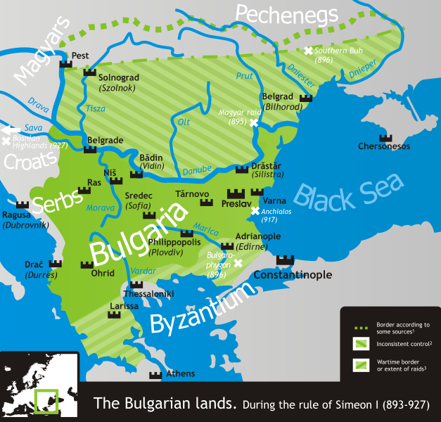
- 1 According to, among others, Crampton, Delev, Dobrev and Lalkov.
- 2 Bulgaria ruled all land east of the Danube and west of the Dnieper according to Constantine VII's De Administrando Imperio (c. 950), but actual Bulgarian control was often partial, weak and/or inconsistent in many of the scarcely-populated areas north of the Danube.
- 3 That is, unconfirmed by a peace treaty and only controlled during military campaigns in the Byzantine lands. These, however, comprised much if not most of Simeon's rule.
- The northern border is conjectural, as its exact location is practically unattested.
References
- Crampton, R.J. (2005年) 《 A Concise History of Bulgaria》、Cambridge University Press、pp. p. 13 ISBN 0521850851
- Delev, Petǎr; Valeri Kacunov, Plamen Mitev, Evgenija Kalinova, Iskra Baeva, Bojan Dobrev (2006年) "9 Bǎlgarskata dǎržava pri Car Simeon" in (bulgarian) 《 Istorija i civilizacija za 11. klas》、Trud, Sirma
- Dobrev, Hristo (1979年) (bulgarian) 《 Bǎlgarski voenen atlas》、索菲亞: Voenno izdatelstvo、pp. pp. 152−153 OCLC 46136451
- Koledarov, Petǎr (1989年) (bulgarian) 《 Političeska geografija na srednovekovnata bǎlgarska dǎržava 2 (1186–1396)》、Bulgarian Academy of Sciences
- Lalkov, Milčo (1997年) 《 Rulers of Bulgaria》、Kibea、pp. p. 24, p. 66 ISBN 954-474-098-8
| 註解 | 該圖片含有註解:在維基媒體共享資源上查看註解 |
.svg)
文件历史
点击某个日期/时间查看对应时刻的文件。
.svg&dir=prev)
.svg&offset=20070304205903)
.svg&offset=&limit=20)
.svg&offset=&limit=50)
.svg&offset=&limit=100)
.svg&offset=&limit=250)
.svg&offset=&limit=500)
| 日期/时间 | 缩略图 | 大小 | 用户 | 备注 | |
|---|---|---|---|---|---|
| 当前 | 2019年11月18日 (一) 14:50 | | 752 × 719(232 KB) | Claude Zygiel | Side |
| 2019年11月18日 (一) 14:49 |  | 744 × 1,052(520 KB) | Claude Zygiel | Details | |
| 2011年2月18日 (五) 20:38 |  | 752 × 719(232 KB) | Ilmari Karonen | add missing xmlns attribute(s) | |
| 2007年3月7日 (三) 20:49 | 没有缩略图 | (232 KB) | Martyr | ||
| 2007年3月6日 (二) 09:13 | 没有缩略图 | (232 KB) | Martyr | ||
| 2007年3月5日 (一) 21:10 | 没有缩略图 | (230 KB) | Martyr | ||
| 2007年3月5日 (一) 20:03 | 没有缩略图 | (230 KB) | Martyr | larger names of battles, etc. | |
| 2007年3月5日 (一) 19:29 | 没有缩略图 | (232 KB) | Martyr | names of some important battles, etc. | |
| 2007年3月5日 (一) 10:22 | 没有缩略图 | (211 KB) | Martyr | river names, Thessaloniki name, rm line (northern border is conjectural), etc. | |
| 2007年3月4日 (日) 20:59 | 没有缩略图 | (194 KB) | Martyr | new |
文件用途
以下页面使用本文件:
全域文件用途
以下其他wiki使用此文件:
- ar.wikipedia.org上的用途
- bn.wikipedia.org上的用途
- ckb.wikipedia.org上的用途
- da.wikipedia.org上的用途
- de.wikipedia.org上的用途
- el.wikipedia.org上的用途
- en.wikipedia.org上的用途
- eo.wikipedia.org上的用途
- es.wikipedia.org上的用途
- eu.wikipedia.org上的用途
- fa.wikipedia.org上的用途
- fr.wikipedia.org上的用途
- he.wikipedia.org上的用途
- hr.wikipedia.org上的用途
- hy.wikipedia.org上的用途
- it.wikipedia.org上的用途
- ja.wikipedia.org上的用途
- ka.wikipedia.org上的用途
- kk.wikipedia.org上的用途
- lt.wikipedia.org上的用途
- lv.wikipedia.org上的用途
- mk.wikipedia.org上的用途
- nds.wikipedia.org上的用途
- nl.wikipedia.org上的用途
- no.wikipedia.org上的用途
- oc.wikipedia.org上的用途
- pl.wikipedia.org上的用途
- pt.wikipedia.org上的用途
查看本文件的更多全域用途。
.svg)
.svg)