
File:BritishEmpire1919.png
本预览的尺寸:800 × 409像素。 其他分辨率:320 × 163像素 | 640 × 327像素 | 1,425 × 728像素。
原始文件 (1,425 × 728像素,文件大小:52 KB,MIME类型:image/png)

|
此historical map图片可使用矢量图形重新创建为SVG文件。这具有很多好处;更多信息请参见共享资源:待清理媒体。如果存在此图片的SVG格式,请将其上传,然后将此模板替换为
{{vector version available|新图片名称}}。
建议您将SVG命名为“BritishEmpire1919.svg”,这样在使用Vector version available(或Vva)模板时就不需要填写新图片名称参数。 |
摘要
| 描述 |
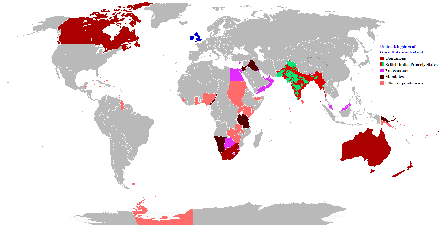
English: Map of the British Empire in 1919 showing all the territories, including the dominions, colonies, protectorates and mandates, ruled or administered by the United Kingdom and its successor states during that year.
Français : Carte de l'Empire britannique en 1919 illustrant tous les territoires, tels que les dominions, colonies, protectorats et mandats, gouvernés ou administrés par le Royaume-Uni ou ses États successeurs cette année-là.
Español: Un mapa de todas las afirmaciones oficiales territorial del Imperio Británico que se celebró en 1919 que identifica qué tipo de celebración estaba presente en todas las posesiones durante ese año.
Deutsch: Eine Karte aller offiziellen territorialen Ansprüche des Britischen Empire, die es im Jahre 1919 hatte, nach Art der Besitzungen in diesem Jahr.
فارسی: نقشه بیمورد از همه ادعاهای ارضی رسمی امپراطوری بریتانیا که در سال 1919 که برای شناسایی نوع برگزاری در حال حاضر تمام اموال در آن سال برگزار شد.
Português: Mapa de todos os territórios reclamados pelo Império Britânico, em 1919, que identifica o tipo de presença britânica no local naquele ano. |
| 日期 | |
| 来源 |
The following: |
| 作者 | Maps & Lucy |
| 授权 (二次使用本文件) |
Released into the public domain (by the author). |
| 其他版本 | العربيَّة |
Legend
Deutsch (de):
许可协议
本文件采用知识共享署名-相同方式共享 2.5 通用许可协议授权。
- 您可以自由地:
- 共享 – 复制、发行并传播本作品
- 修改 – 改编作品
- 惟须遵守下列条件:
- 署名 – 您必须对作品进行署名,提供授权条款的链接,并说明是否对原始内容进行了更改。您可以用任何合理的方式来署名,但不得以任何方式表明许可人认可您或您的使用。
- 相同方式共享 – 如果您再混合、转换或者基于本作品进行创作,您必须以与原先许可协议相同或相兼容的许可协议分发您贡献的作品。
文件历史
点击某个日期/时间查看对应时刻的文件。
| 日期/时间 | 缩略图 | 大小 | 用户 | 备注 | |
|---|---|---|---|---|---|
| 当前 | 2021年10月31日 (日) 08:26 | | 1,425 × 728(52 KB) | Randomastwritter | jubaland |
| 2014年11月17日 (一) 20:43 |  | 1,425 × 728(61 KB) | GrenaderGD44 | Убраны артефакты с карты в районе Антарктиды | |
| 2014年11月17日 (一) 01:40 |  | 1,425 × 728(65 KB) | GrenaderGD44 | Бутан - протекторат с 1910 года | |
| 2014年3月9日 (日) 18:36 |  | 1,425 × 625(39 KB) | Htonl | Bechuanaland, Basutoland and Swaziland were protectorates | |
| 2011年6月18日 (六) 20:02 |  | 1,425 × 625(55 KB) | Maps & Lucy | The British Empire, Mongolia and the Soviet Union all recognized Tibet as an independent state and the British Empire via British India were heavily involved in Tibet's independence. | |
| 2011年5月7日 (六) 19:05 |  | 1,425 × 625(58 KB) | Quigley | Correct China's borders closer to what was internationally recognized at the time | |
| 2010年12月15日 (三) 23:55 |  | 1,425 × 625(55 KB) | Maps & Lucy | Added protectorates and Princely States | |
| 2010年12月10日 (五) 22:47 |  | 1,425 × 625(53 KB) | Maps & Lucy | Papua was a colony not a dominion, Gold Coast did not include British Togoland and British Togoland was a mandate. | |
| 2010年11月7日 (日) 18:20 |  | 1,425 × 625(59 KB) | Spesh531 | fix mistake in botswana | |
| 2010年11月7日 (日) 18:19 |  | 1,425 × 625(56 KB) | Spesh531 | really a way to revert. use this version |
文件用途
以下2个页面使用本文件:
全域文件用途
以下其他wiki使用此文件:
- af.wikipedia.org上的用途
- ar.wikipedia.org上的用途
- azb.wikipedia.org上的用途
- az.wikipedia.org上的用途
- ba.wikipedia.org上的用途
- be-tarask.wikipedia.org上的用途
- be.wikipedia.org上的用途
- bg.wikipedia.org上的用途
- bs.wikipedia.org上的用途
- bxr.wikipedia.org上的用途
- cdo.wikipedia.org上的用途
- de.wikipedia.org上的用途
- el.wikipedia.org上的用途
- en.wikipedia.org上的用途
- eo.wikipedia.org上的用途
- fiu-vro.wikipedia.org上的用途
- fi.wikipedia.org上的用途
- fr.wikipedia.org上的用途
- he.wikipedia.org上的用途
- hif.wikipedia.org上的用途
- hr.wikipedia.org上的用途
- hy.wikipedia.org上的用途
- ia.wikipedia.org上的用途
- id.wikipedia.org上的用途
- is.wikipedia.org上的用途
- ja.wikipedia.org上的用途
- kk.wikipedia.org上的用途
- krc.wikipedia.org上的用途
- lez.wikipedia.org上的用途
- lo.wikipedia.org上的用途
- lv.wikipedia.org上的用途
- ms.wikipedia.org上的用途
- mwl.wikipedia.org上的用途
- my.wikipedia.org上的用途
- nl.wikipedia.org上的用途
- nn.wikipedia.org上的用途
- pnb.wikipedia.org上的用途
- qu.wikipedia.org上的用途
- ru.wikipedia.org上的用途
查看本文件的更多全域用途。