
File:Arzviller plan incline 01.jpg

本预览的尺寸:800 × 524像素。 其他分辨率:320 × 209像素 | 640 × 419像素 | 1,024 × 670像素 | 1,280 × 838像素 | 2,502 × 1,638像素。
原始文件 (2,502 × 1,638像素,文件大小:1.63 MB,MIME类型:image/jpeg)
| 描述 |
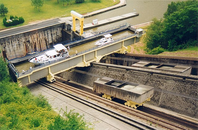
Français : Plan incliné de Saint-Louis-Arzviller
Nederlands: Hellend vlak van St-Louis-Arzviller
English: Saint-Louis-Arzviller inclined plane |
| 日期 | |
| 来源 | Photographie prise par GIRAUD Patrick |
| 作者 | User Calips on fr.wikipedia |
| 授权 (二次使用本文件) |
本文件采用知识共享署名-相同方式共享 1.0 通用许可协议授权。
|
| 其他版本 |
Originally from fr.wikipedia; description page was here
|
| 相机位置 | | 在以下服务上查看本图像和附近其他图像: OpenStreetMap |
|---|
(Uploaded using CommonsHelper or PushForCommons archive copy at the Wayback Machine)
文件历史
点击某个日期/时间查看对应时刻的文件。
| 日期/时间 | 缩略图 | 大小 | 用户 | 备注 | |
|---|---|---|---|---|---|
| 当前 | 2006年10月31日 (二) 09:07 | | 2,502 × 1,638(1.63 MB) | Korrigan | {{Information| |Description= Plan incliné de Saint-Louis-Arzviller Photographie prise par GIRAUD Patrick |Source= |Date= |Author=User Calips on [http://fr.wikipedia.org fr.wikipedia] |Permission={{CC-BY-SA}} |other_versions= Originall |
文件用途
以下页面使用本文件:
全域文件用途
以下其他wiki使用此文件:
- als.wikipedia.org上的用途
- cs.wikipedia.org上的用途
- de.wikipedia.org上的用途
- en.wikipedia.org上的用途
- eo.wikipedia.org上的用途
- fr.wikipedia.org上的用途
- Transport fluvial en France
- Canal de la Marne au Rhin
- Plan incliné de Saint-Louis-Arzviller
- Ascenseur à bateaux
- Utilisateur:Calips
- Portail:Lorraine/Lumière
- Portail:Lorraine/Lumière-14
- Wikipédia:Le Bistro/18 juin 2006
- Wikipédia:Le Bistro/Galerie/2006
- Sentier de grande randonnée 532
- Wikipédia:Le Bistro/Galerie/Juin
- 1969 en Lorraine
- fr.wiktionary.org上的用途
- ja.wikipedia.org上的用途
- lb.wikipedia.org上的用途
- nl.wikipedia.org上的用途
- pl.wikipedia.org上的用途
- ru.wikipedia.org上的用途
- sv.wikipedia.org上的用途
- uk.wikipedia.org上的用途
- www.wikidata.org上的用途