
File:Amphitheatre Drakensberg.jpg

本预览的尺寸:800 × 533像素。 其他分辨率:320 × 213像素 | 640 × 427像素 | 1,024 × 683像素 | 1,280 × 853像素 | 2,496 × 1,664像素。
原始文件 (2,496 × 1,664像素,文件大小:1.11 MB,MIME类型:image/jpeg)
摘要
| 相机位置 | | 在以下服务上查看本图像和附近其他图像: OpenStreetMap |
|---|
| 描述 |
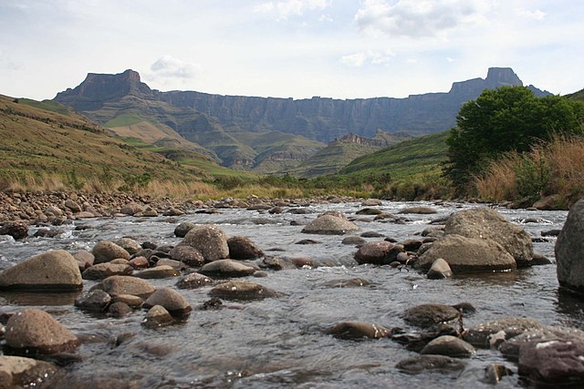
Afrikaans: Gesig op die Drakensbergamfiteater vanaf die Tugelarivier se boloop, KwaZulu-Natal, Suid-Afrika
English: View of the Drakensberg amphitheatre as from the upper Tugela River, KwaZulu-Natal, South Africa |
| 日期 | 8 January 2007 (uploaded) |
| 来源 | Taken by Rudolph Botha on 21 October 2006. Image taken from en.wiki ([1]) |
| 作者 | User:Bothar |
| 授权 (二次使用本文件) |
Released into public domain |
![[1]](https://en.wikipedia.org/wiki/Image:Amphitheatre_Drakensberg.jpg)
原始上传日志
* (del) (cur) 07:37, 8 January 2007 . . Bothar (Talk | contribs) . . 2496×1664 (1,166,280 bytes) (Taken by Rudolph Botha on 2006/10/21. View of the Amphitheatre as from the Tugela River, South Africa.)
许可协议
| 本作品已被作者英语维基百科的Bothar释出到公有领域。这适用于全世界。 在一些国家这可能不合法;如果是这样的话,那么: Bothar无条件地授予任何人以任何目的使用本作品的权利,除非这些条件是法律规定所必需的。 |
文件历史
点击某个日期/时间查看对应时刻的文件。
| 日期/时间 | 缩略图 | 大小 | 用户 | 备注 | |
|---|---|---|---|---|---|
| 当前 | 2007年5月30日 (三) 13:36 | | 2,496 × 1,664(1.11 MB) | Jalo | Image taken from en.wiki ([http://en.wikipedia.org/wiki/Image:Amphitheatre_Drakensberg.jpg]) ==Original description== Taken by Rudolph Botha on 2006/10/21. View of the Amphitheatre as from the Tugela River, South Africa. ==Original history== <pre> * (d |
文件用途
以下页面使用本文件:
全域文件用途
以下其他wiki使用此文件:
- af.wikipedia.org上的用途
- arz.wikipedia.org上的用途
- azb.wikipedia.org上的用途
- be-tarask.wikipedia.org上的用途
- ca.wikipedia.org上的用途
- ceb.wikipedia.org上的用途
- cs.wikipedia.org上的用途
- en.wikipedia.org上的用途
- en.wikivoyage.org上的用途
- es.wikipedia.org上的用途
- et.wikipedia.org上的用途
- fr.wikipedia.org上的用途
- he.wikipedia.org上的用途
- hr.wikipedia.org上的用途
- it.wikipedia.org上的用途
- it.wikivoyage.org上的用途
- lt.wikipedia.org上的用途
- ml.wikipedia.org上的用途
- ms.wikipedia.org上的用途
- my.wikipedia.org上的用途
- nn.wikipedia.org上的用途
- no.wikipedia.org上的用途
- pl.wikipedia.org上的用途
- pt.wikipedia.org上的用途
- ru.wikipedia.org上的用途
- sh.wikipedia.org上的用途
- sk.wikipedia.org上的用途
- ss.wikipedia.org上的用途
- sv.wikipedia.org上的用途
- sw.wikipedia.org上的用途
- uk.wikipedia.org上的用途
- www.wikidata.org上的用途
- xmf.wikipedia.org上的用途