
File:Americas independence map.PNG

本预览的尺寸:407 × 600像素。 其他分辨率:163 × 240像素 | 326 × 480像素 | 862 × 1,270像素。
原始文件 (862 × 1,270像素,文件大小:74 KB,MIME类型:image/png)

|
此historical map图片可使用矢量图形重新创建为SVG文件。这具有很多好处;更多信息请参见共享资源:待清理媒体。如果存在此图片的SVG格式,请将其上传,然后将此模板替换为
{{vector version available|新图片名称}}。
建议您将SVG命名为“Americas independence map.svg”,这样在使用Vector version available(或Vva)模板时就不需要填写新图片名称参数。 |
摘要
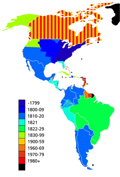
Map showing date of independence of country in the Americas. Black shows areas not yet independent.
Uses current boundaries, which may not correspond with the historical boundary of the country when it became independent. For example the United States was composed of 13 states on the East Coast when it became independent and did not reach its full continental extant until 1867 with the .
许可协议

|
已授权您依据自由软件基金会发行的无固定段落及封面封底文字(Invariant Sections, Front-Cover Texts, and Back-Cover Texts)的GNU自由文件许可协议1.2版或任意后续版本的条款,复制、传播和/或修改本文件。该协议的副本请见“GNU Free Documentation License”。 |
| 本文件采用知识共享署名-相同方式共享 3.0 未本地化版本许可协议授权。 | ||
| ||
| 本许可协议标签作为GFDL许可协议更新的组成部分被添加至本文件。 |
文件历史
点击某个日期/时间查看对应时刻的文件。
| 日期/时间 | 缩略图 | 大小 | 用户 | 备注 | |
|---|---|---|---|---|---|
| 当前 | 2019年5月11日 (六) 14:23 | | 862 × 1,270(74 KB) | Foghe | Removed Labrador border; only current international borders. |
| 2019年4月25日 (四) 03:32 |  | 862 × 1,270(44 KB) | Marcomogollon | I add disputed territory between Colombia, Ecuador and Peru | |
| 2011年10月3日 (一) 23:11 |  | 862 × 1,270(68 KB) | Lemonade100 | Added some current dependent territories and re-coded Canada - gained sovereignty in 1939 and full independence in 1982. | |
| 2010年11月9日 (二) 18:35 |  | 862 × 1,270(38 KB) | Minnecologies | Fixed error in northern Canada | |
| 2010年11月9日 (二) 17:25 |  | 862 × 1,270(38 KB) | Minnecologies | *Filled in Pacific Northwest *Added Saint Pierre and Miquelon *Updated the boundaries of Gran Colombia, Bolivia, and Peru *Changed color scheme to straight ROYGBIV | |
| 2007年8月20日 (一) 06:32 |  | 862 × 1,270(61 KB) | AlexCovarrubias | Mexico independence year is 1810 | |
| 2006年12月7日 (四) 00:48 |  | 862 × 1,270(49 KB) | Roke~commonswiki | include colonies | |
| 2006年3月22日 (三) 12:48 |  | 862 × 1,270(63 KB) | Roke~commonswiki | Map showing date of independence of country in the Americas Category: America |
文件用途
以下页面使用本文件:
全域文件用途
以下其他wiki使用此文件:
- ar.wikipedia.org上的用途
- bg.wikipedia.org上的用途
- cs.wikipedia.org上的用途
- de.wikipedia.org上的用途
- en.wikipedia.org上的用途
- es.wikipedia.org上的用途
- fa.wikipedia.org上的用途
- fi.wikipedia.org上的用途
- fr.wikipedia.org上的用途
- fy.wikipedia.org上的用途
- gl.wikipedia.org上的用途
- ja.wikipedia.org上的用途
- kn.wikipedia.org上的用途
- ms.wikipedia.org上的用途
- nds-nl.wikipedia.org上的用途
- nl.wikipedia.org上的用途
- pt.wikipedia.org上的用途
- sd.wikinews.org上的用途
- uk.wikipedia.org上的用途
- www.wikidata.org上的用途
- wo.wikipedia.org上的用途