File:AmchitkaAlaskaLoc.png

页面内容不支持其他语言。
這個文件來自維基共享資源
维基百科,自由的百科全书

AmchitkaAlaskaLoc.png(300 × 219像素,文件大小:14 KB,MIME类型:image/png


摘要

描述

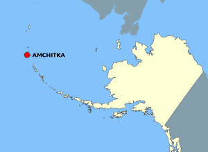
This map is a derivative work of a map layer from nationalatlas.gov, which states: "We have begun by collaboratively building "frameworks," the essential map layers that provide a foundation for all other maps. These basic layers, including small-scale harmonized information on North American roads, water, boundaries and the like, are being offered here for the first time. Like all other raw data and documentation offered here on nationalatlas.gov, these frameworks can be downloaded at no cost and used freely without copyright concerns or license restrictions."[1]

I donate the modifications and the resulting work to the public domain.
来源 see above
作者 National Atlas - DW: Jakew

许可协议

Public domain
本地圖取自美國國家地圖集的某個版本。國家地圖集的絕大多數作品是美國聯邦政府的作品,因此屬於公有領域
連結網址︰ NationalAtlas.gov | 1970年印刷版︰ 國會檔案館, Perry-Castañeda圖書館

čeština | Deutsch | English | français | Bahasa Indonesia | italiano | македонски | മലയാളം | sicilianu | 中文 | 中文(简体)‎ | 中文(繁體)‎ | +/−

原始上传日志

原始描述頁面位於這裡。下列使用者名稱均來自en.wikipedia。
  • 2006-10-08 16:15 Jakew 300×219×8 (14678 bytes) This map is a derivative work of a map layer from nationalatlas.gov, which states: "We have begun by collaboratively building "frameworks," the essential map layers that provide a foundation for all other maps. These basic layers, including small-scale ha

说明

添加一行文字以描述该文件所表现的内容

此文件中描述的项目

描繪內容

29373e1014db60b020fe042aeb20de37cd506fdd

14,678 字节

219 像素

300 像素

文件历史

点击某个日期/时间查看对应时刻的文件。

日期/时间缩⁠略⁠图大小用户备注
当前2007年8月2日 (四) 21:202007年8月2日 (四) 21:20版本的缩略图300 × 219(14 KB)Adam~commonswiki{{Information |Description=This map is a derivative work of a map layer from nationalatlas.gov, which states: "We have begun by collaboratively building "frameworks," the essential map layers that provide a foundation for all other maps. These basic layer

以下页面使用本文件:

全域文件用途

以下其他wiki使用此文件: