
File:Airports in Norway map.svg

此SVG文件的PNG预览的大小:501 × 526像素。 其他分辨率:229 × 240像素 | 457 × 480像素 | 731 × 768像素 | 975 × 1,024像素 | 1,951 × 2,048像素。
原始文件 (SVG文件,尺寸为501 × 526像素,文件大小:166 KB)
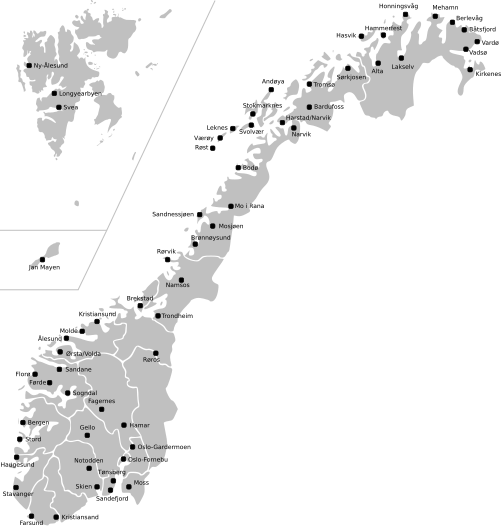
| 描述 | Map of Norway with all current and former public and military airports. This excludes private airports without scheduled services. Note: Svalbard and Jan Mayen are not to scale, and not geographically correctly located in relation to each other and mainland Norway. The accuracy of the map makes accurate placement of the airports sometimes a little off. |
| 日期 | (UTC) |
| 来源 | |
| 作者 |
|
本文件采用知识共享署名-相同方式共享 3.0 未本地化版本许可协议授权。
- 您可以自由地:
- 共享 – 复制、发行并传播本作品
- 修改 – 改编作品
- 惟须遵守下列条件:
- 署名 – 您必须对作品进行署名,提供授权条款的链接,并说明是否对原始内容进行了更改。您可以用任何合理的方式来署名,但不得以任何方式表明许可人认可您或您的使用。
- 相同方式共享 – 如果您再混合、转换或者基于本作品进行创作,您必须以与原先许可协议相同或相兼容的许可协议分发您贡献的作品。
原始上传日志
This image is a derivative work of the following images:
- File:Norway_counties_blank.svg licensed with Cc-by-sa-2.5
- 2008-07-16T09:52:07Z ZorroIII 256x256 (84546 Bytes) Correct county code for Telemark
- 2007-09-21T21:39:11Z Marmelad 256x256 (84546 Bytes) added information about regions
- 2007-09-21T21:24:01Z Marmelad 256x256 (84348 Bytes) forgot to remove example colouring
- 2007-09-21T21:23:01Z Marmelad 256x256 (84340 Bytes) {{Information |Description=Blank map of Norwegian counties, used e.g. to create locator maps. |Source=Based on [[:Image:Norway counties.svg]] |Date=2007-09-21 |Author=[[User:Marmelad|Marmelad]] |Permission= {{cc-by-sa-2.5}}
- File:Svalbard_outline.svg licensed with PD-self
- 2009-04-28T10:05:31Z Arsenikk 200x265 (39847 Bytes) {{Information |Description={{en|1=Vector outline map of Svalbard, Norway.}} |Source=Own work by uploader |Author=[[User:Arsenikk|Arsenikk]] |Date=2009-04-29 |Permission= |other_versions= }} [[Category:Maps of Svalbard]] [[C
- File:Jan_Mayen_outline.svg licensed with PD-self
- 2009-09-12T10:29:46Z Arsenikk 294x267 (8401 Bytes) {{Information |Description=Blank map of Jan Mayen (Norway) |Source=*[[:File:Jan_Mayen_blank.jpg|]] |Date=2009-09-12 10:28 (UTC) |Author=*[[:File:Jan_Mayen_blank.jpg|]]: Alfanje *derivative work: ~~~ |Permission=see below |oth
Uploaded with derivativeFX
文件历史
点击某个日期/时间查看对应时刻的文件。
| 日期/时间 | 缩略图 | 大小 | 用户 | 备注 | |
|---|---|---|---|---|---|
| 当前 | 2021年5月2日 (日) 11:23 | | 501 × 526(166 KB) | BIL | I moved some airports slightly to reflect their actual position |
| 2009年9月12日 (六) 12:15 |  | 501 × 526(170 KB) | Arsenikk | {{Information |Description=Map of Norway with all current and former public and military airports. This excludes private airports without scheduled services. Note: Svalbard and Jan Mayen are not to scale, and not geographically correctly located in relati |
文件用途
全域文件用途
以下其他wiki使用此文件:
- en.wikipedia.org上的用途
- fa.wikipedia.org上的用途
- fr.wikipedia.org上的用途
- it.wikipedia.org上的用途
- no.wikipedia.org上的用途
- uk.wikipedia.org上的用途