
File:676029main pia16052-color-full full.jpg
原始文件 (1,449 × 1,089像素,文件大小:481 KB,MIME类型:image/jpeg)
摘要
| 描述 |
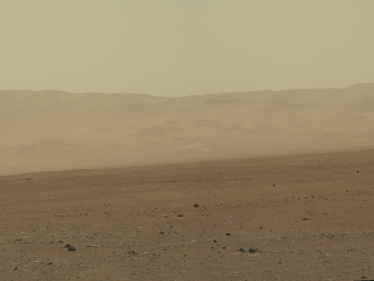
English: This image of the crater wall is north of the landing site, or behind the rover. Here, a network of valleys believed to have formed by water erosion enters Gale Crater from the outside. This is the first view scientists have had of a fluvial system - one relating to a river or stream -- from the surface of Mars. Known and studied since the 1970s beginning with NASA's Viking missions, such networks date from a period in Martian history when water flowed freely across the surface. The main channel deposit seen here resembles a dirt road ascending into the mountains, which are actually the north wall and rim of Gale Crater.
Although Curiosity is about 11 miles (18 kilometers) away from this area and the view is obscured somewhat by dust and haze, the image provides new insights into the style of sediment transport within this system. Curiosity has no current plans to visit this valley system, since the primary objective of the rover is south of the landing site. But images taken later and with the 100-millimeter Mastcam are likely to allow scientists to study the area in significantly more detail. The images in this mosaic were acquired by the 34-millimeter MastCam over about an hour of time on 8 Aug. 2012 PDT (9 Aug. 2012 EDT), each at 1,200 by 1,200 pixels in size. ALSO NOTE: Curiosity rover view from Bradbury Landing (9 August 2012)[1] See => https://www.nasa.gov/mission_pages/msl/multimedia/pia16052-color.htmlReferences
NASA's Mars Science Laboratory Image Wall of Gale Crater https://www.nasa.gov/mission_pages/msl/multimedia/pia16052-color.html This color image from NASA's Curiosity rover shows part of the wall of Gale Crater, the location on Mars where the rover landed on 5 Aug. 2012 PDT (6 Aug. 2012 EDT). This is part of a larger, high-resolution color mosaic made from images obtained by Curiosity's Mast Camera. This image of the crater wall is north of the landing site, or behind the rover. Here, a network of valleys believed to have formed by water erosion enters Gale Crater from the outside. This is the first view scientists have had of a fluvial system - one relating to a river or stream -- from the surface of Mars. Known and studied since the 1970s beginning with NASA's Viking missions, such networks date from a period in Martian history when water flowed freely across the surface. The main channel deposit seen here resembles a dirt road ascending into the mountains, which are actually the north wall and rim of Gale Crater. Although Curiosity is about 11 miles (18 kilometers) away from this area and the view is obscured somewhat by dust and haze, the image provides new insights into the style of sediment transport within this system. Curiosity has no current plans to visit this valley system, since the primary objective of the rover is south of the landing site. But images taken later and with the 100-millimeter Mastcam are likely to allow scientists to study the area in significantly more detail. The images in this mosaic were acquired by the 34-millimeter MastCam over about an hour of time on 8 Aug. 2012 PDT (9 Aug. 2012 EDT), each at 1,200 by 1,200 pixels in size. |
| 日期 | |
| 来源 | http://www.nasa.gov/mission_pages/msl/multimedia/pia16052-color.html |
| 作者 | NASA/JPL-Caltech/MSSS |
许可协议
| 本文件完全由NASA创作,在美国属于公有领域。根据NASA的版权方针,NASA的材料除非另有声明否则不受版权保护。(参见Template:PD-USGov/zh、NASA版权方针页面或JPL图片使用方针。) | ||
 |
警告:
|
文件历史
点击某个日期/时间查看对应时刻的文件。
| 日期/时间 | 缩略图 | 大小 | 用户 | 备注 | |
|---|---|---|---|---|---|
| 当前 | 2012年8月12日 (日) 05:43 | | 1,449 × 1,089(481 KB) | Havebased123 |
文件用途
全域文件用途
以下其他wiki使用此文件:
- ca.wikipedia.org上的用途
- en.wikipedia.org上的用途
- es.wikipedia.org上的用途
- ja.wikipedia.org上的用途
- ro.wikipedia.org上的用途
- ru.wikinews.org上的用途