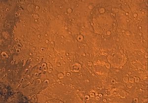
阿拉伯方格区
外观
(重定向自阿拉伯区)
| 阿拉伯方格區 | |
|---|---|
 來自火星軌道器雷射高度计的阿拉伯方格區地圖。海拔最高處是紅色,最低處是藍色。 | |
| 坐标 | 15°00′N 337°30′W / 15°N 337.5°W |

阿拉伯方格區(Arabia quadrangle)是美國地質調查局太空地質学研究計划對火星表面畫分的30個火星地圖方格之一,編號為MC-12[1]。
這個方格包含大部分火星傳統的阿拉伯高地,它也包含一部分的示巴高地和小部分的子午線高原。它位於年輕的北方平原邊界和古老的南方高地之間。方格涵蓋的區域從西經315°至360°,和北緯0°至30°。
其它的火星方格
[编辑]相關條目
[编辑]- 火星氣候
- Dark slope streak
- Equatorial Layered Deposits
- 火星地質
- Groundwater on Mars
- 火星方格區列表
- Pedestal craters
- Vallis
- 火星水文
參考資料
[编辑]- ^ Davies, M.E.; Batson, R.M.; Wu, S.S.C. "Geodesy and Cartography" in Kieffer, H.H.; Jakosky, B.M.; Snyder, C.W.; Matthews, M.S., Eds. Mars. University of Arizona Press: Tucson, 1992.
- ^ Morton, Oliver. Mapping Mars: Science, Imagination, and the Birth of a World. New York: Picador USA. 2002: 98. ISBN 0-312-24551-3.
- ^ Online Atlas of Mars. Ralphaeschliman.com. [December 16, 2012].
- ^ PIA03467: The MGS MOC Wide Angle Map of Mars. Photojournal. NASA / Jet Propulsion Laboratory. February 16, 2002 [December 16, 2012].

